
One of my most favorite places in the whole world (that I've never actually been to) is The Giant's Causeway in northern Ireland.
The summer after college I was a nanny for my cousins in a small town outside of Dublin called Dunboyne. I was too young to get my Irish driver's license and ended up taking the kids to the city on the bus. We did get to take weekend trips with the family to southern Ireland, but while I was there there was just too much unrest to visit up North.
Thus, this is the most amazing place in the world that I've always wanted to go to, but never have. :)
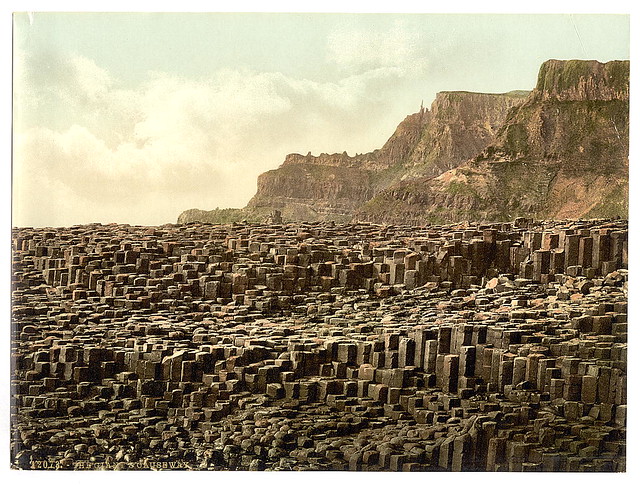
 The Giant's Causeway is a natural formation of rocks on the northern coast between Ireland and Scotland. As you can see from the photos, these spires of rock form beautiful polygons, often hexagons, but reports are anything from quadrilaterals to nonagons.
 This, to me, is full of opportunities for great instruction. I can see anything from estimation and basic polygon identification (3rd Grade) to tessellations and transformations.
 For this reason, I feel the EQUATE model is a perfect opportunity to explore these photos and this location. Rather than focusing on a single grade, I encourage you to use the EQUATE thinking routine to apply appropriate standards at your grade level.
Grade Level: 3-HS
Course: Math, Pre-Alg, Algebra, Geometry
Standards: 3.MD.8, 3.G.1, 3.G.2, 4.MD.5, 4.G.1, 4.G.2, 4.G.3, 5.MD.5, 5.G.3, 5.G.4, 6.G.1, 6.G.2, 6.G.3, 6.G.4, 7.EE.3, 7.EE.4, 7.G.1, 7.G.6, 8.G.1, 8.G.2, 8.G.3, 8.G.4, G-CO.1, G-CO.2, G-CO.5, G-CO.6, G-CO.7, G-GPE.7, G-GMD.2, G-GMD.3, G-MD.1, G-MD.3
SMP: MP.1, MP.2, MP.3, MP.4, MP.5, MP.6, MP.7, MP.8
Skills: Estimation, Number sense, reasoning, modeling, geometry, geometric shapes, properties of shapes, area, perimeter, volume.
How to use this as a mad minute:
You have 60 seconds. Name all of the shapes you can see.
How to use this as a warm up:
You could ask the students to consider one of the following:
1. Name the shapes you see.
2. Does this fit the definition of a tessellation? Why or why not?
3. Are these "regular" polygons? Why or why not?
How to use this as a mini-lesson:
If I only had 20 minutes, I would use technology to explore this VERY COOL region. This website has an awesome interactive map, some history, and the legend of the Giant's Causeway.
http://www.voicesfromthedawn.com/the-giants-causeway/
How to use this as a full lesson?
As I mentioned before, I feel that this is an ideal EQUATE lesson. Although there is a ton of math that is obvious to an instructor, this captivates my interest because of the combination of legend, scientific history, and visual appeal. I feel your students will also be drawn to these elements. If you are comfortable, let the students dictate the direction of the lesson and exploration (within reason).
I would show these photos, let the students explore, discuss, etc.
Then I would list all of their questions, encouraging them to "wonder mathematically" about them.
Focused on grade-level appropriate standards, I would ask students to narrow down the questions to make sure they are relevant to things you have already explored or discussed in your class.
I would let the students ask YOU questions and you can provide the answers you feel are appropriate. (How are they formed? How big is the region? How many are there? You can provide as much or as little information as you wish.)
I would settle on a question (or two or three) for your students to apply their knowledge and continue to try to solve. Encourage them to TRY something! Draw on the photo, measure it, get online and do research, look up formulas that might be useful, gather information, start playing with the numbers, rules, formulas, photos, etc.
Finally, ask the students to Explain what they did, what they found, and how they approached the problem.
How to use this as an assessment?
It is up to you if you think your students can use this as an assessment appropriately.
It could be something as simple as providing the first photo and asking students to outline as many different shapes as they can see and explain why they are different and what they are (Elementary School).
It could be more advanced, offering the size of the region, the size of an individual "step" and asking the students to estimate how many are in the entire region. (Upper Elementary to Middle School.)
You could ask the students to find two similar "steps" and justify why they are similar (Middle/High).
You could ask the students to find the volume of two or three different "steps" and justify their solution methods. (Middle/High).
You could ask the students to PROVE that two items are congruent or similar based on transformations such as rotations, reflections, etc.
Works Cited:
Photo 1
Description: Giant's Causeway and Causeway Coast
Copyright: © Philippe Croo
Author: Philippe Croo
Image Source: Philippe Croo (Link)
Photo 2
http://farm3.staticflickr.com/2755/4427445338_7869405855_z.jpg?zz=1
Photo 3
https://garystravel.wordpress.com/page/107/
Please feel free to use any of these ideas and modify them to meet your needs. However, please acknowledge the original source of the items and my own lesson outlines. ©NatalieRSprigg 2013